Arctic Digital Twin Helps Scientists Restore Melting Coasts
Scientists built a virtual copy of Svalbard's coastlines to help restoration teams fight erosion and climate change in the fastest-warming region on Earth. The interactive tool makes complex data accessible to anyone working to protect Arctic shores.
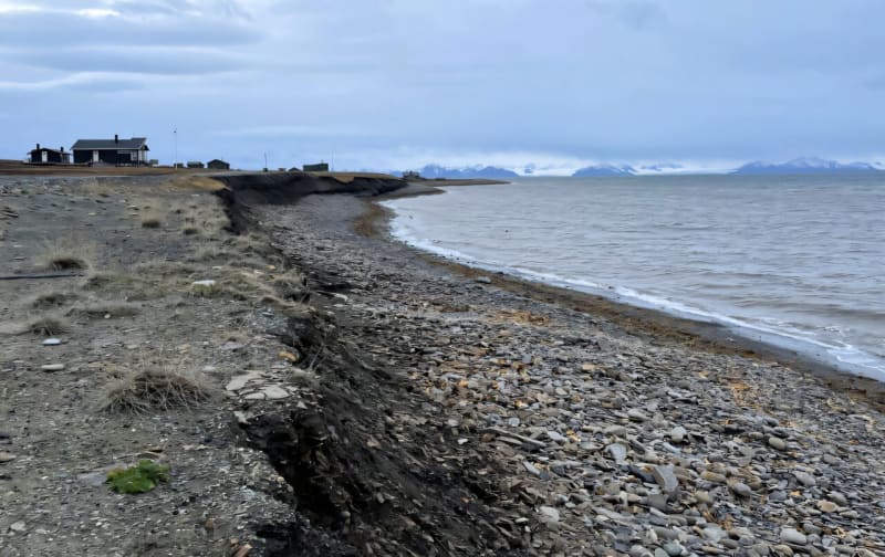
The Arctic is changing faster than almost anywhere on Earth, but now scientists have a powerful new way to fight back.
Researchers in Norway have created a digital twin of Svalbard, a complete virtual copy of the Arctic archipelago's vulnerable coastlines. This isn't just a map. It's an interactive simulation that lets restoration teams test solutions before implementing them in the real world.
Think of it like a video game version of Svalbard, except the data is real and the stakes are enormous. The platform combines drone footage, wave patterns, sea ice measurements, and tourism data into one place where users can explore different "what if" scenarios.
Lara Veylit, a researcher at SINTEF, explains it simply. "We're guiding users to use the best available science and hopefully allowing for data-driven decision making that could shape the future of the Arctic."
The tool is part of a larger marine restoration project across Europe called Climarest. Five regional digital twins are helping restore everything from Irish seagrass meadows to French oyster reefs, but the Arctic version faces the most urgent crisis.
Svalbard is warming faster than most places on the planet. Its coastlines battle erosion from melting ice, stronger waves, and increasing human activity. The digital twin gives restoration teams a way to understand these threats without expensive trial and error.
What makes this project special is how it tells stories alongside the science. Users don't just see static graphs. They explore maps of settlements, watch drone videos of eroding beaches, and track how tourist numbers affect fragile ecosystems over time.
The platform even lets users slide through future climate scenarios to see what Svalbard might look like in 10 or 20 years. All the code and data are free to use, running on computing power that anyone can access through a tool called Jupyter notebook.
The Ripple Effect
This breakthrough extends far beyond one Arctic archipelago. The team made all their data publicly available following something called FAIR principles: findable, accessible, interoperable, and reusable.
That means drone images, wave models, and biodiversity surveys that once sat locked on hard drives are now available to scientists and restoration workers worldwide. It's a massive step toward transparent, collaborative environmental science.
The digital twin will be hosted on two major European data platforms to ensure it stays available for decades. Even after the Climarest project ends this November, restoration teams can keep using these tools to protect vulnerable coastlines.
Ida Øverjordet, who coordinates the project, sees this as just the beginning. The approach could work anywhere facing similar threats, from Alaska to Antarctica.
Right now, the platform is helping real restoration practitioners make real decisions about nature-based solutions in Svalbard. They can test which coastline protections might work best before spending time and money building them in one of Earth's harshest environments.
The Arctic is changing, but now the people working to protect it have a crystal-clear view of what they're up against and the tools to build a more resilient future.
More Images

Based on reporting by Phys.org - Earth
This story was written by BrightWire based on verified news reports.
Spread the positivity! 🌟
Share this good news with someone who needs it