Satellite Design Tool Cuts Space Collision Risk by 50%
Scientists created a tool that helps satellites gather climate data without turning space into a debris field. It could protect astronauts and satellites as orbital traffic explodes toward 100,000 spacecraft by 2030.
Space is getting dangerously crowded, but researchers at The University of Manchester just created a solution that lets us keep using satellites to fight climate change without risking catastrophic collisions.
The team developed a new design tool that helps engineers build Earth-observation satellites with collision risk factored in from day one. Right now, most missions focus on image quality first and worry about crashes later, but that approach is becoming unsustainable as space fills up.
There are currently 11,800 active satellites orbiting Earth. That number could skyrocket to over 100,000 by 2030. Every collision creates debris that threatens other satellites, astronauts, and our ability to use space for critical missions like climate monitoring and disaster response.
Lead researcher John Mackintosh calls it a "space sustainability paradox." We need satellites to solve environmental challenges on Earth, but launching too many without careful planning could make space unusable for everyone.
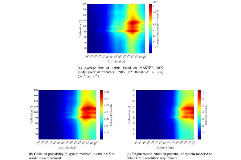
The new model revealed surprising insights about where danger really lurks. Scientists found that collision risk doesn't peak where debris is most concentrated. Satellite size matters just as much as location.
For a satellite capturing half-meter resolution images, collision probability maxed out between 850 and 950 kilometers above Earth. That's about 50 kilometers higher than the densest debris zone because satellites at that altitude need to be much larger.
The Ripple Effect
This breakthrough means mission designers can now balance two competing needs: gathering high-quality data to track deforestation, monitor crops, and respond to disasters while keeping space safe for future generations.
The tool shows that lower orbits require more satellites to cover the same area, but each one can be smaller and less hazardous. Higher orbits need fewer satellites, but those spacecraft must be much larger, creating greater collision risk if something goes wrong.
Dr. Ciara McGrath, who worked on the project, emphasizes the tool offers a practical path forward as satellite use explodes. Instead of choosing between Earth's environment and space's environment, we can protect both.
The framework can adapt to different satellite systems and could eventually account for how long debris stays in orbit and what happens when satellites reenter Earth's atmosphere. That would give designers the complete sustainability picture before committing to a mission design.
The research appears in the journal Advances in Space Research, arriving just as governments and private companies race to launch mega-constellations for internet access and Earth monitoring. With this tool, they can build those networks responsibly, ensuring space remains accessible for everyone who needs it.
More Images


Based on reporting by Phys.org
This story was written by BrightWire based on verified news reports.
Spread the positivity!
Share this good news with someone who needs it