
Scientists Create Risk Maps to Protect Communities from Hantavirus
Researchers at Los Alamos National Laboratory have developed groundbreaking risk maps that will help public health officials protect vulnerable communities from hantavirus, especially in underserved areas. This innovative tool combines environmental, social, and ecological data to predict where people need protection most, potentially saving countless lives.
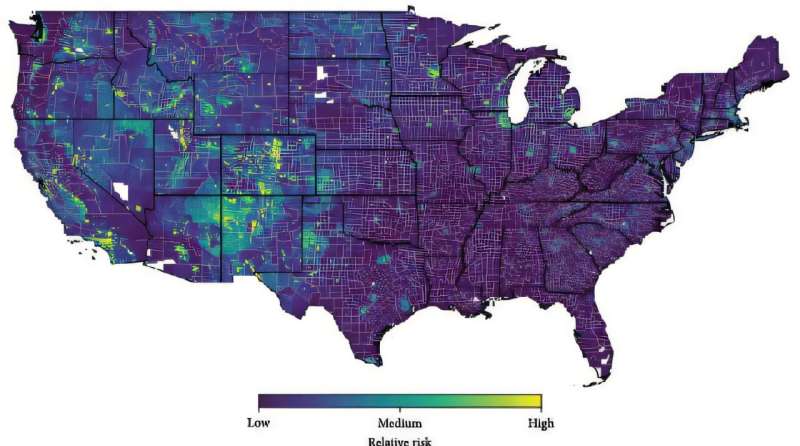
In a remarkable effort to safeguard public health, scientists at Los Alamos National Laboratory have created comprehensive risk maps that could transform how communities protect themselves from hantavirus. This innovative research represents the first time experts have examined the combined effects of environmental conditions, land use patterns, socioeconomic factors, and wildlife populations to predict disease risk across the entire contiguous United States.
Lead researcher Morgan Gorris and her team analyzed nearly three decades of data from 1993 to 2022, developing detailed maps that show exactly where people face the greatest exposure risks. The breakthrough lies not just in identifying danger zones, but in providing public health officials with actionable information they can use to protect the most vulnerable populations.
The research reveals important patterns that can guide prevention efforts. The team discovered that drier western regions face higher risks, but this knowledge empowers communities to take targeted precautions. Understanding that arid climates allow the virus to persist longer in the environment means people in these areas can implement specific protective measures around barns, sheds, and outdoor workspaces.
Perhaps most importantly, the study highlights areas where human development meets natural habitats, what researchers call "fringe" zones. Co-author Andrew Bartlow emphasizes that this finding points toward a solution: creating buffer zones between development and wildlife habitats. This insight echoes successful conservation strategies used worldwide and offers a clear path forward for communities planning new development.
The Ripple Effect
The positive implications of this research extend far beyond simply identifying risk areas. By pinpointing the specific factors that increase hantavirus exposure, the study empowers communities, developers, and public health officials to make informed decisions that protect both people and wildlife habitats.
The research team's comprehensive approach means that regions previously thought to be low risk can now receive appropriate attention if conditions suggest underreporting of cases. This could lead to better healthcare access and education in underserved rural areas, ultimately strengthening the entire public health infrastructure.
The study also opens exciting new avenues for future research, particularly regarding how different rodent populations interact with their environments. Understanding these ecological relationships could lead to wildlife management strategies that reduce disease transmission while preserving important ecosystems.
Public health officials now have a powerful tool for developing targeted mitigation strategies, especially for socioeconomically vulnerable populations who may lack resources for prevention. Rather than applying blanket recommendations across diverse geographic areas, communities can now focus their efforts where they'll have the greatest impact.
The research demonstrates how scientific innovation can directly improve lives, particularly for people in rural and developing areas who often have limited access to healthcare resources. By combining environmental science, public health, and community planning, this study exemplifies the kind of collaborative, solutions-focused research that makes our world safer and healthier for everyone.
More Images


Based on reporting by Medical Xpress
This story was written by BrightWire based on verified news reports.
Spread the positivity! 🌟
Share this good news with someone who needs it
More Good News
 Health & Wellness
Revolutionary Vaccine Technology Promises Better Protection Against Respiratory Viruses
 Health & Wellness
UK Shoppers Champion Traffic Light Food Labels to Support Healthier Choices
 Health & Wellness
Global Health Progress: 38 Countries Show Strong Commitment to Child Vaccination
DAILY MORALE
What did the thermometer say to the graduated cylinder?
EXPLORE INTEL
DAILY INSPIRATION
Hope is the thing with feathers that perches in the soul and sings the tune without the words and never stops at all.
Emily Dickinson