Scientists Map Sinking Deltas to Help 236M People Prepare
New satellite mapping reveals exactly how fast the world's river deltas are sinking, giving communities the data they need to fight flooding before it's too late. The breakthrough research shows where to focus efforts now, potentially saving millions from rising waters.
Scientists just handed 236 million people living in river deltas a powerful new tool to protect their homes from flooding.
Researchers at UC Irvine used satellite radar to measure sinking land across 40 major river deltas worldwide, creating the first detailed map of exactly where and how fast the ground is dropping. The breakthrough gives communities precise data to fight back against flooding with targeted solutions.
"These results give delta communities a clearer picture of an additional threat," said lead author Leonard Ohenhen, a UC Irvine professor of Earth system science. The clarity matters because knowing your actual risk changes how you respond.
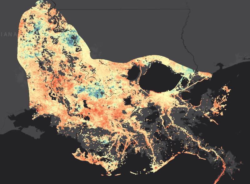
The team discovered that in most deltas, the land is sinking faster than sea levels are rising. Some areas in China's Yellow River Delta drop more than one centimeter each year, while Louisiana's Mississippi Delta sinks 3.3 millimeters annually. In the Mekong, Chao Phraya, and Nile deltas, vast stretches are losing elevation faster than the seas around them are climbing.
The biggest culprit? Human activity. Pumping groundwater drives the sinking in 35 percent of the deltas studied. Cities also compress the ground beneath them, and dams upstream starve deltas of sediment that once replenished the land naturally.
Here's the hopeful twist: Unlike rising seas driven by global climate change, these local causes have local solutions. Communities can manage groundwater better, restore natural sediment flow, and build smarter infrastructure right now.
The Bright Side
This research transforms an invisible threat into something communities can measure and fight. The Mississippi Delta has documented its sinking for years, and the new data confirms those patterns while revealing which specific areas need attention most urgently.
When you know groundwater pumping causes your problem, you can regulate wells. When sediment starvation is the issue, you can modify dam operations or add sediment artificially. These aren't distant future solutions requiring global cooperation. They're actions local governments and communities can take today.
The satellite data continues collecting information, giving planners real-time updates on whether their interventions work. It's like having a continuous health monitor for the ground beneath your feet.
While climate-driven sea level rise remains a long-term challenge requiring global action, these findings show that communities don't have to wait helplessly. They can prioritize the most effective local investments to buy time and reduce flooding exposure for millions of people.
Knowledge has always been the first step toward protection, and now delta communities worldwide have the map they need to start building resilience from the ground up.
More Images

Based on reporting by Google News - Scientists Discover
This story was written by BrightWire based on verified news reports.
Spread the positivity! 🌟
Share this good news with someone who needs it


