AI Maps Every Tree in Forests Using Radar Technology
Purdue researchers developed AI that creates 3D maps of individual trees using remote sensing, transforming how we monitor and protect forests. The breakthrough could revolutionize conservation efforts worldwide.
Scientists just taught computers to see the forest AND the trees.
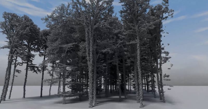
Researchers at Purdue University's College of Agriculture developed artificial intelligence that can identify and map individual trees in dense forests using radar technology. The system creates detailed 3D reconstructions from remote sensing data, turning what used to require weeks of manual fieldwork into something that happens in hours.
Traditional forest surveys meant sending teams into rugged terrain with measuring tapes and clipboards. They'd catalog trees one by one, a process that was slow, expensive, and often dangerous in remote areas.
The new AI changes everything. It processes radar data from aircraft or satellites to build precise digital models of forest landscapes, distinguishing individual trees even when their canopies overlap. The technology can measure tree height, crown size, and density across thousands of acres in the time it once took to survey a single plot.
The Ripple Effect
This breakthrough arrives exactly when the world needs it most. Countries around the globe are racing to meet reforestation commitments and combat climate change, but you can't protect what you can't measure.
The AI gives conservationists, governments, and land managers a powerful new tool. They can now track forest health in real time, spot illegal logging faster, and measure carbon storage with unprecedented accuracy. Indigenous communities protecting ancestral forests gain scientific backup for their stewardship efforts.
Forest carbon credit programs, which fund conservation by valuing the CO2 trees absorb, can finally verify their impact reliably. That means more funding flowing to protect existing forests and restore damaged ones.
The technology works in places humans struggle to reach: steep mountainsides, swamps, areas prone to wildfires. Researchers can monitor ecosystem recovery after disasters without waiting years for ground teams to assess the damage.
Early tests show the AI achieves accuracy levels comparable to on-the-ground surveys. As the system learns from more data, it keeps getting smarter, recognizing different tree species and detecting subtle changes that signal disease or drought stress before visible symptoms appear.
Purdue's team is already working with conservation organizations to deploy the technology in tropical rainforests, where biodiversity is highest but monitoring is hardest.
What started as an engineering challenge became a lifeline for the planet's lungs.
Based on reporting by Google News - Researchers Find
This story was written by BrightWire based on verified news reports.
Spread the positivity!
Share this good news with someone who needs it