NASA Satellite Turns South African Farms Into Rainbow Art
A new Earth-observing satellite is creating stunning rainbow maps of farmland while helping scientists track crops and protect food security. The colorful images from NASA and India's joint mission show how technology can be both beautiful and lifesaving.
A NASA satellite just turned South African farmland into a breathtaking rainbow quilt, and the pretty colors are actually saving lives.
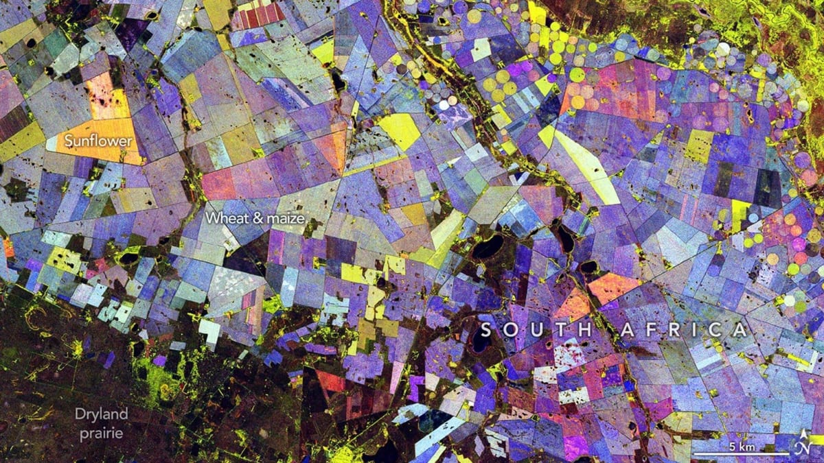
The NISAR satellite, launched in July 2025 as a partnership between NASA and India's space agency, captured stunning composite images of agricultural land along South Africa's Vet River. Each vibrant color tells a story: green shows healthy vegetation, red marks bare soil, and blue shades reveal how quickly crops are growing.
The region north of Bloemfontein sits in South Africa's Maize Triangle, one of the country's most important agricultural areas. The satellite tracks everything from corn and sunflower fields to forests, distinguishing between them based on plant size and growth patterns.
"It's a pretty picture, but there are also important things that it communicates to us," said Paul Siqueira, a scientist at the University of Massachusetts Amherst who leads the NISAR ecosystems team. The satellite can tell different crops apart because of how they grow and change through the seasons.
NISAR doesn't just make art. The satellite monitors natural disasters, tracks glacier melt, studies ecosystems, and helps farmers optimize their crops. By watching how vegetation changes week by week, scientists can spot drought stress, disease, or pest damage before it destroys entire harvests.
This matters especially for regions like the Maize Triangle, where local communities depend on successful growing seasons. Early warning systems powered by satellite data give farmers precious time to respond to threats.
Why This Inspires
Technology often feels cold and distant, but NISAR shows how innovation can be both stunning and practical. The same data that creates gallery-worthy abstract art also helps predict food shortages and protect vulnerable communities from climate disasters.
The joint mission between American and Indian space agencies proves what's possible when countries collaborate on solving global challenges. While NISAR watches over crops in South Africa today, it's simultaneously tracking forests in the Amazon, glaciers in the Himalayas, and coastal changes worldwide.
Every rainbow pixel represents real progress toward a more resilient planet.
More Images

Based on reporting by Space.com
This story was written by BrightWire based on verified news reports.
Spread the positivity!
Share this good news with someone who needs it