NASA's New Flying Camera Maps Earthquakes From 41,000 Feet
Scientists just launched an aircraft-mounted camera system that could help predict earthquakes and save lives by creating ultra-detailed 3D maps of Earth's surface. The breakthrough technology bridges the gap between satellite and ground observations, offering new hope for understanding natural disasters before they strike.
Imagine if we could see earthquakes coming the way meteorologists now forecast hurricanes. That future just got closer thanks to a team of scientists who took eight cameras, mounted them on a jet, and pointed them straight down at the planet.
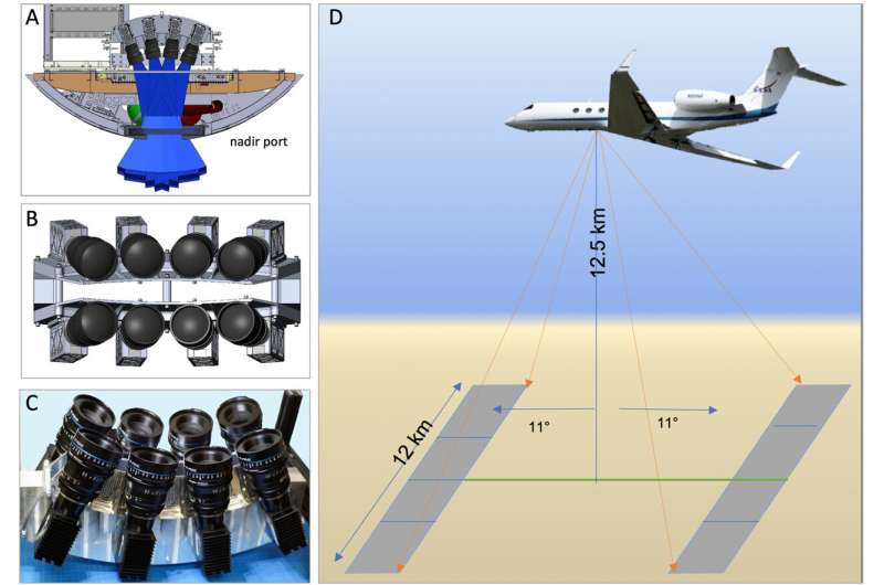
Andrea Donnellan, a professor at Purdue University, leads the team behind QUAKES-I, a new instrument that flies at 41,000 feet creating incredibly detailed color 3D maps of Earth's surface. The system captures 12-kilometer-wide swaths of terrain with resolution far better than most satellites can achieve.
"The history of Earth processes is written in the landscapes," Donnellan explains. By studying how Earth's surface shifts and changes, her team can track the movements that lead to earthquakes, sometimes measuring changes as small as millimeters.
The technology works like standing up to find a lost contact lens instead of crawling on the floor. Sometimes the best view comes from stepping back and changing your perspective.
QUAKES-I doesn't just study earthquakes. The system also tracks volcanoes, wildfires, erosion, glaciers, ecosystems, infrastructure, and vegetation. It can deploy quickly to gather targeted data wherever scientists need it most, filling the gap between slower satellites and smaller drones.
The instrument is part of NASA's Surface Topography and Vegetation program, which combines radar, lidar, and stereo imaging from air and space. Together, these tools create the clearest digital map of our dynamic planet ever made.
Why This Inspires
Right now, predicting earthquakes remains largely a mystery. Some quakes happen along famous faults like California's San Andreas, but others strike with little warning in unexpected places.
Donnellan's work focuses on measuring position and strain at tectonic faults and their surrounding landscapes. She asks critical questions: How do different conditions in Earth's crust affect earthquake likelihood? When a major quake hits, does it make nearby tremors more or less likely?
The answers could transform how we protect communities. Just as weather forecasting evolved from guesswork to precise science, earthquake prediction might follow the same path.
From her early days measuring Antarctic glaciers in meters as an undergraduate to now tracking millimeter-scale movements across fault lines, Donnellan has watched technology transform Earth science. "I like precise measurements and watching things move to understand the underlying physics," she says.
The QUAKES-I system represents years of development and collaboration between universities and NASA. It can attach to various aircraft and work alongside other instruments, making it a flexible tool for researchers worldwide.
Each flight generates massive amounts of data that scientists will use to understand not just where earthquakes might strike, but why they happen and how we might prepare. The color component adds context that black-and-white lidar imaging cannot provide, revealing details about terrain and vegetation that matter for understanding geological processes.
Better earthquake forecasting could give people precious time to seek shelter, shut down critical infrastructure safely, and mobilize emergency services before disaster strikes.
More Images


Based on reporting by Phys.org - Earth
This story was written by BrightWire based on verified news reports.
Spread the positivity! 🌟
Share this good news with someone who needs it