New Satellite Sees Through Clouds to Watch Earth's Changes
A groundbreaking Earth-monitoring satellite just proved it can see what others can't, capturing stunning images of Mount St. Helens right through thick cloud cover. This technology could transform how we track environmental changes and natural disasters.
A powerful new eye in the sky is giving scientists an unprecedented view of our changing planet, and it can see straight through the weather.
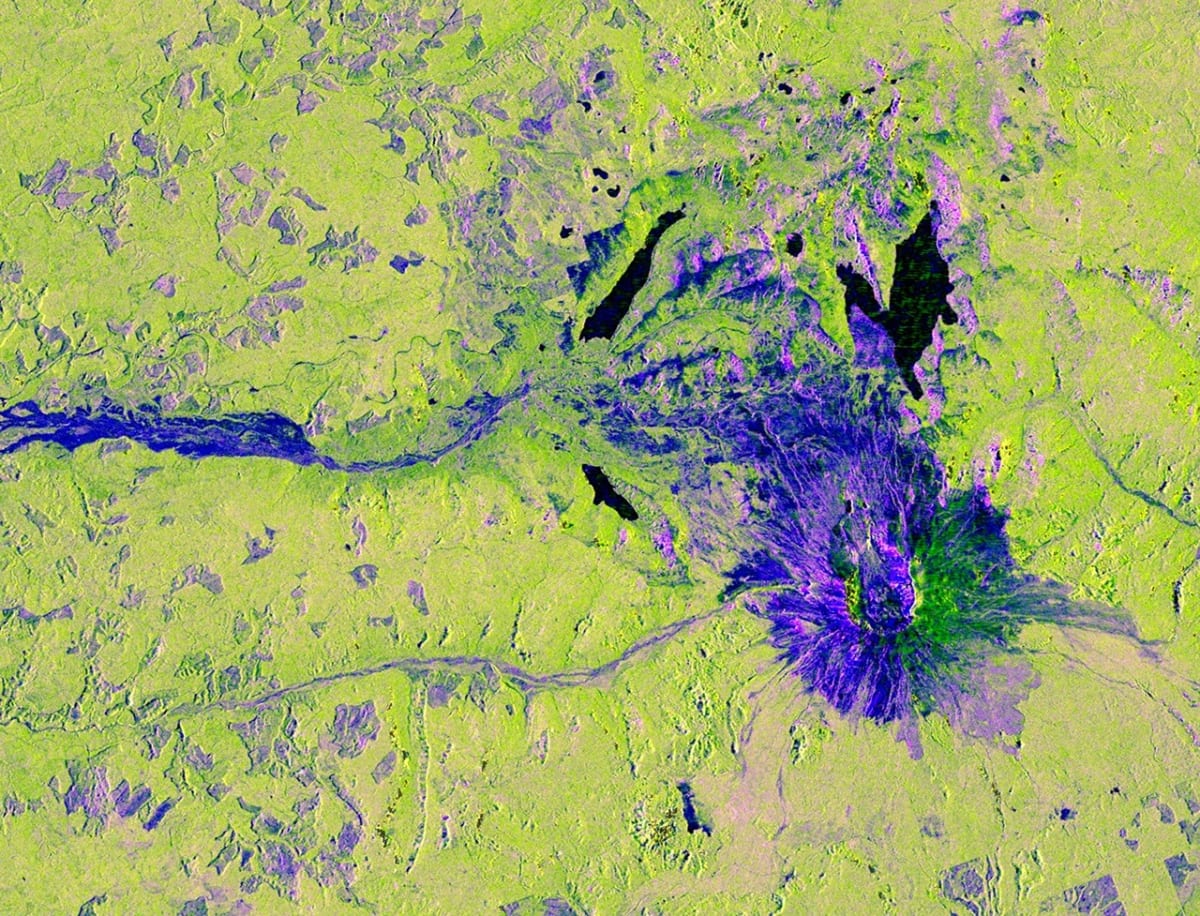
The NISAR satellite, a joint mission between NASA and India's space agency, captured its first stunning images of Washington's Mount St. Helens in November 2025. While clouds blanketed the Pacific Northwest that day, the satellite's radar technology pierced right through them to reveal the landscape below in remarkable detail.
The image shows far more than just a pretty picture of a famous volcano. Different colors reveal secrets about the land: green patches indicate forests and wetlands, dark blue shows smooth surfaces like water, and magenta highlights where radar signals bounce off flat surfaces like roads and buildings. Near the mountain's base, purple squares reveal where humans have thinned forests, their precise right angles standing out against nature's irregular patterns.
What makes NISAR special is its size and ambition. The satellite carries the largest radar antenna reflector NASA has ever sent to space, measuring 39 feet wide. It's also the first spacecraft to use two different radar wavelengths simultaneously, giving scientists a more complete picture of what's happening on the ground.
NISAR launched in July 2025 from India's southeastern coast, representing years of collaboration between American and Indian scientists. JPL at Caltech leads the U.S. side, providing the satellite's L-band radar and massive antenna reflector, while ISRO contributed the spacecraft itself and its S-band radar system.
Why This Inspires
Every 12 days, NISAR will scan Earth's entire land and ice surfaces, creating a continuous record of how our planet changes. Scientists will use this data to track everything from volcanic activity to melting glaciers, deforestation to earthquake damage. When disasters strike, emergency responders will have clear images regardless of weather conditions blocking traditional satellites.
The collaboration between two nations on such an ambitious project shows what's possible when countries work together toward a common goal. This isn't just about cool technology. It's about giving humanity better tools to understand and protect our home planet during a time of rapid environmental change.
Mount St. Helens, which famously erupted in 1980, now serves as proof that we've gained a powerful new tool for watching over Earth's most dynamic and important places.
More Images

Based on reporting by NASA
This story was written by BrightWire based on verified news reports.
Spread the positivity!
Share this good news with someone who needs it