Robe Locals Get Drones to Track Coast Erosion
An Australian coastal town is turning residents into citizen scientists with drones to monitor how quickly their shoreline is disappearing. The two-year project gives locals free equipment and training to help protect their community's future.
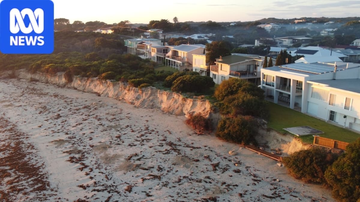
When Tina van Nispen walks the beaches near her home in Robe, South Australia, she's been watching the sand disappear bit by bit. Now she's about to see the changes from a whole new perspective.
Flinders University is recruiting local drone pilots to help measure coastal erosion threatening this seaside town. The researchers are giving participants low-cost drones and training, asking them to capture images once a month and after major storms over the next two years.
The project is part of a national research initiative to increase coastal monitoring across Australia. By involving community members, scientists can cover more coastline and track more storm events than ever before.
Robe needs the help. The town's coastline is eroding fast, with nearly 10 meters of cliffs near the historic lighthouse collapsing in July 2025. Properties at Hoopers Beach are now at risk, and the town's iconic obelisk stands threatened.
District Council CEO Nat Traeger says the community is deeply concerned. While the council already uses its own drone for some imagery, having volunteers gather data on a regular schedule will significantly boost their resources and help secure future funding for protection measures.
The approach is simple but powerful. Local volunteers collect the images, then experts analyze them to calculate changes in shoreline position and sand volume. The data will help coastal managers decide the best strategies for each location, whether that's sand replenishment, managed retreat, or adaptation.
The Ripple Effect
Van Nispen, who's never flown a drone before, jumped at the chance to participate. As a nature lover, she's excited not just about tracking erosion but about other potential uses for the technology, like monitoring seagrass movement.
The model has already proven successful in Victoria, where a similar citizen science project has been gathering storm impact data. If Robe's pilot program works as well, researchers plan to expand it across other South Australian coastal communities.
Associate Professor Graziela Miot da Silva says any interested councils are welcome to join. The team selected Robe partly because existing coastal data and ongoing projects provided a strong foundation, but the program isn't exclusive.
Van Nispen captures the spirit of the project perfectly: protecting and loving the environment so everyone can flourish together. Armed with drones and determination, Robe's residents are taking coastal conservation into their own hands, one flight at a time.
More Images


Based on reporting by ABC Australia
This story was written by BrightWire based on verified news reports.
Spread the positivity!
Share this good news with someone who needs it