US Groundwater Map Reveals 13 Great Lakes Underground
Scientists just created the most detailed map ever of America's hidden water reserves, revealing enough groundwater to fill the Great Lakes 13 times over. The breakthrough could help communities better manage their most precious resource.
Scientists just discovered America has been sitting on a massive water fortune we barely knew existed.
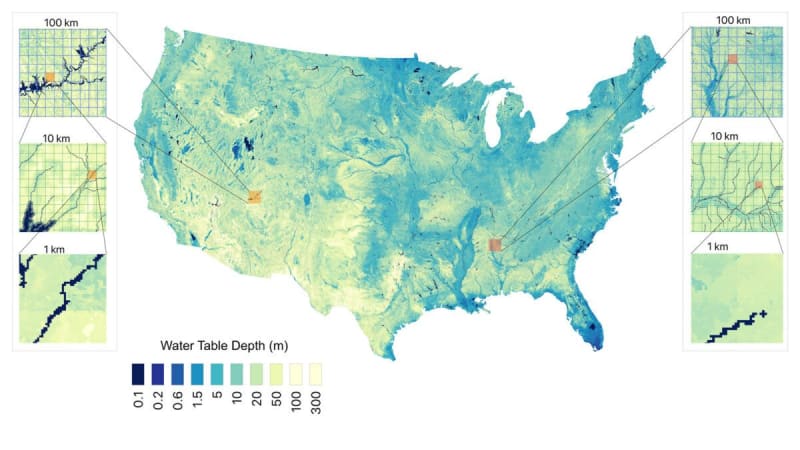
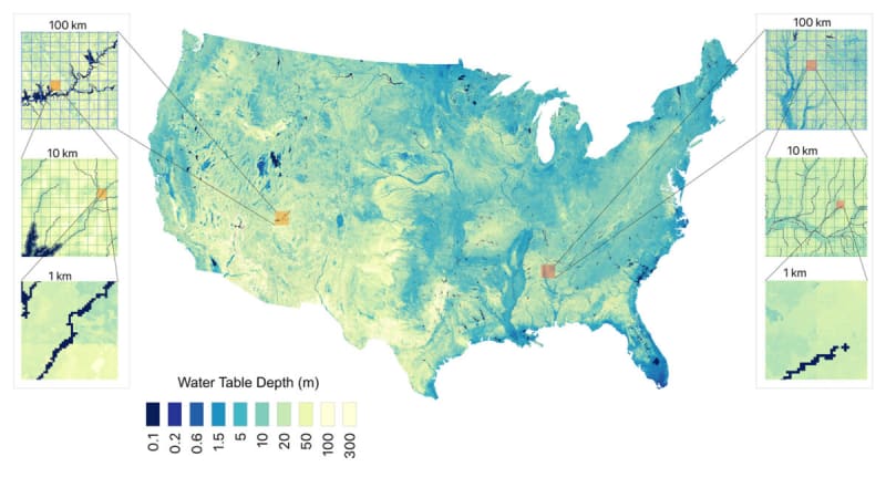
A new groundwater map reveals the contiguous United States holds about 306,500 cubic kilometers of water underground. That's 13 times the volume of all five Great Lakes combined, hidden beneath our feet in soil and rock.
The map, created by researchers at Princeton University and the University of Arizona, offers something never before possible: a clear picture of where America's groundwater actually is. Previous estimates ranged wildly from 159,000 to 570,000 cubic kilometers because scientists were essentially guessing based on scattered data points.
"We're operating in a situation where we don't know how much is going into the savings account every month, and we don't know how much is in our savings account," explained Reed Maxwell, a hydrologist at Princeton University. He compares surface water like rivers and lakes to a checking account for short-term needs, while groundwater serves as long-term savings.
The team combined direct measurements from wells across the country with artificial intelligence to create their map at 30-meter resolution. That's about 10,000 times more detailed than previous satellite-based estimates.
Why does resolution matter? When researchers deliberately downgraded their own map to match older, coarser models, the estimated water volume dropped by 18 percent. Those missing details represent billions of gallons communities thought they had access to.
The challenge has always been that only 1 percent of Earth's freshwater sits on the surface where we can see it. The other 99 percent hides underground, and measuring it has meant relying on scattered wells that act like "pinpricks into the subsurface," said Laura Condon, a University of Arizona hydrologist who co-authored the study.
Even worse, wells cluster in areas where groundwater is plentiful, leaving drier regions poorly understood exactly where better data matters most.
Why This Inspires
This map represents more than scientific achievement. It's a roadmap for hope in an era of water uncertainty.
Communities across the American West face tough decisions about water use as droughts become more common. Farmers wonder whether to plant. City planners debate growth limits. Families worry about wells running dry.
Now, for the first time, local leaders can see their underground water reserves with unprecedented clarity. They can plan smarter, conserve better, and make decisions based on facts rather than fear.
The research shows that knowledge itself is a resource. When we understand what we have, we can protect it, share it fairly, and ensure it lasts for generations to come.
Understanding our hidden water wealth is the first step toward securing it for the future.
More Images



Based on reporting by Live Science
This story was written by BrightWire based on verified news reports.
Spread the positivity!
Share this good news with someone who needs it