AI Helps Feed Millions and Map Disaster Zones Safely
Space rover technology is now delivering food through war zones and minefields without risking aid workers' lives. Machine learning maps earthquakes in days and predicts hunger crises 90 days ahead.
Getting food to people trapped in conflict zones or flooded areas has always meant putting aid workers in mortal danger, but technology designed for Mars rovers is changing that.
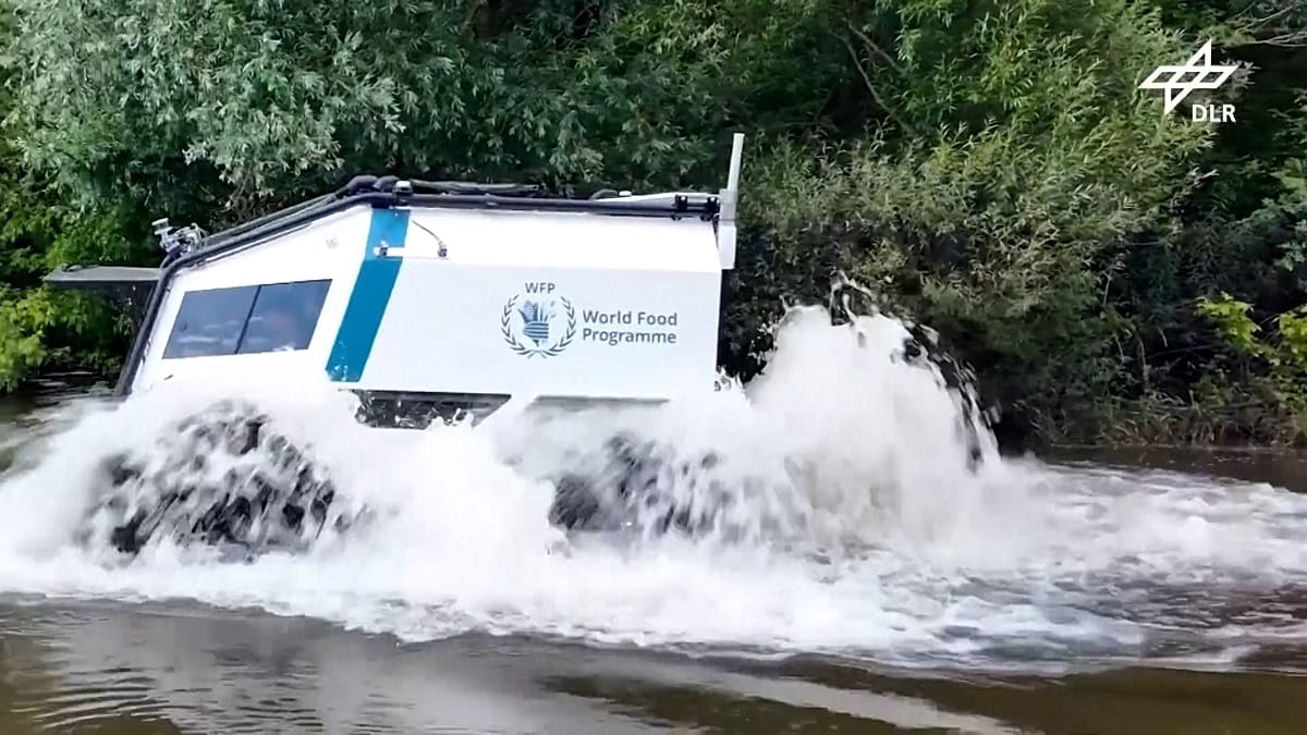
Project AHEAD, a collaboration between the World Food Programme, Germany's aerospace research center, and the Red Cross, is bringing remotely operated vehicles to some of the world's most dangerous humanitarian missions. The same sensors and control systems built to explore Mars's moon Phobos now guide all-terrain vehicles through minefields and flood zones with no one behind the wheel.
The technology is already being tested in Germany, where footage shows unmanned vehicles wading through open water and climbing over rough ground. An operator controls everything remotely, allowing supplies to reach people in areas too risky for conventional delivery trucks.
But physical deliveries are just the beginning. The World Food Programme's HungerMap Live platform uses machine learning to track food insecurity across more than 95 countries in near-real time, combining data on conflict, weather, climate hazards, and economic conditions.
"You can get real-time data, and right now we're even looking into forecasting food security 90 days into the future," said Bernhard Kowatsch, director of the WFP's Global Accelerator division. Anyone can access the publicly available platform online to see where hunger crises are emerging.
When two powerful earthquakes struck northern Venezuela in June, limited map data made it nearly impossible to know where people needed help most. The Humanitarian OpenStreetMap Team used AI to extract building information from satellite images, then mobilized over 600 volunteers through their MapSwipe app to mark damaged areas.
"Within four days after the earthquake, we were able to mobilize more than 600 volunteers that were basically swiping left and right on the mobile app," said Leen D'hondt, the organization's director of technology and data. That speed helped early responders deliver food and supplies to the right neighborhoods immediately.
The Ripple Effect
While manual mapping still provides better quality, D'hondt points out that speed can save lives when disasters strike. Knowing roughly where buildings are and how many people live there can mean the difference between getting help to survivors in time or arriving too late.
The technology isn't yet routine in most emergency responses worldwide, though India and Europe have operational AI-based warning systems. But every test, every successful delivery, and every mapped disaster zone brings this life-saving technology closer to becoming standard practice.
What started as a way to explore distant planets is now helping feed millions and keep aid workers safe while they do it.
More Images

Based on reporting by Euronews
This story was written by BrightWire based on verified news reports.
Spread the positivity!
Share this good news with someone who needs it