MIT Satellites Could Give GPS to Moon-Bound Spacecraft
MIT researchers are developing satellite beacons that would create a GPS-like navigation system for spacecraft traveling between Earth and the moon. The technology could make lunar missions safer and more reliable for the growing wave of exploration ahead.
Astronauts traveling to the moon currently navigate like sailors before lighthouses existed, but MIT researchers just designed the cosmic equivalent of those guiding beacons.
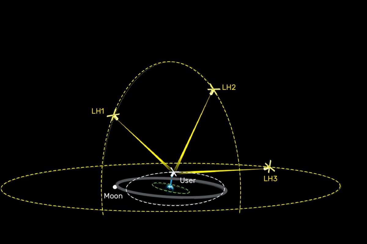
Scientists at MIT Lincoln Laboratory are developing LightHOUSE, a constellation of satellites that would provide GPS-like navigation for spacecraft journeying between Earth and the moon. Right now, missions in this vast region called cislunar space rely on NASA's Deep Space Network, an accurate but overtaxed system of Earth-based radio antennas that can only support a few missions at a time.
The current system has serious limitations. Determining a spacecraft's precise position can take hours, and astronauts experience complete communication blackouts when passing behind the moon, like the 40-minute silence during Artemis II.
LightHOUSE satellites would orbit at extremely high altitudes, up to roughly 1 million miles from Earth. From these positions, they would use laser beams to exchange timing signals with spacecraft and track their locations against the backdrop of stars, providing real-time navigation data across the entire Earth-moon region.
The system is designed with user-friendliness in mind. The beacon satellites would carry the heavy technical load with large telescopes and powerful lasers, while spacecraft would need only small, lightweight equipment to receive the signals.
"Nearly all space missions require some degree of precision navigation and timing, but no global positioning system exists in this domain," says Aaron Greenberg, a technical staff member at MIT. LightHOUSE would fill that critical gap.
The technology builds on MIT's proven expertise in optical communications, including recent successes with NASA programs. The team is combining laser communication systems with high-resolution imaging to track spacecraft more than half a million miles from Earth.
The Ripple Effect
This navigation network could transform lunar exploration. Spacecraft would need fewer corrective maneuvers, saving precious fuel for their missions. Ground-based systems would be freed up to support more missions simultaneously. Most importantly, astronauts and robotic spacecraft alike would have constant, reliable positioning data, even when Earth isn't visible.
The MIT team is now refining their design through simulations and lab experiments. They're planning to publish detailed architecture specifications soon, with the ultimate goal of making navigation beyond Earth's orbit as routine and reliable as using GPS to find a coffee shop.
As NASA's Artemis program and commercial space ventures ramp up lunar missions, LightHOUSE could become the invisible infrastructure that makes the new era of moon exploration possible.
The future of space travel is getting brighter, one laser beam at a time.
Based on reporting by MIT News
This story was written by BrightWire based on verified news reports.
Spread the positivity!
Share this good news with someone who needs it