Scientists Map Hidden Antarctica in Stunning New Detail
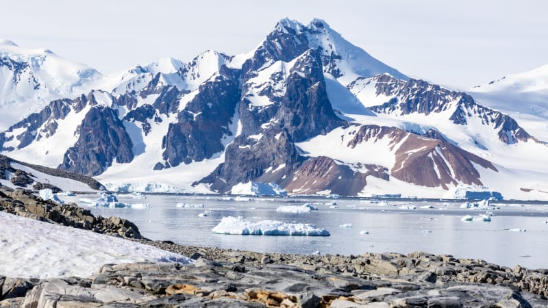
Researchers have created the most detailed map ever of what lies beneath Antarctica's massive ice sheets, revealing thousands of hidden hills, ridges, and mountain ranges for the first time. This breakthrough could help predict how quickly the frozen continent will melt and what that means for coastal cities worldwide.
Imagine exploring a continent where we know less about what's under the ice than we do about the surface of Mars.
Scientists just changed that. Researchers at the University of Grenoble-Alpes and the University of Edinburgh created the most detailed map ever of Antarctica's hidden landscape, revealing what lies beneath ice that's up to three miles thick in places.
Dr. Helen Ockenden, who led the study, describes the difference like upgrading from a grainy film camera to a high-resolution digital zoom. The team discovered tens of thousands of hills and ridges that no one knew existed, plus crystal-clear views of buried mountain ranges and canyons.
The breakthrough came from combining satellite images of Antarctica's icy surface with physics principles about how glaciers move. When ice flows over hidden hills or ridges in the bedrock below, it creates patterns on the surface, like eddies forming over rocks in a river. By reading these patterns, scientists could map the hidden terrain without drilling through miles of ice.
Traditional radar surveys from planes only scanned narrow tracks across the continent, sometimes tens of kilometers apart. Picture trying to map the Scottish Highlands or European Alps by flying over them just once every 20 miles. You'd miss entire mountain ranges.
One surprising find is a massive channel carved into the ice bed in an area called the Maud Subglacial Basin. The channel runs for nearly 400 kilometers, about the distance from London to Newcastle, and averages 50 meters deep and 6 kilometers wide.
Why This Inspires
This map represents more than just filling in blank spaces on a chart. Understanding Antarctica's hidden landscape helps scientists predict how fast glaciers will melt as the planet warms, which directly affects sea-level rise for coastal communities everywhere.
Professor Robert Bingham, a glaciologist at the University of Edinburgh who worked on the study, can barely contain his excitement. "I'm just so excited to look at that and just see the whole bed of Antarctica at once," he said. "I think that's amazing."
The hidden ridges, mountains, and valleys ultimately shape how fast glaciers above them move and retreat. Better maps mean better computer models. Better models mean clearer predictions about Antarctica's future and what it means for the millions of people living in coastal cities around the world.
Dr. Peter Fretwell from the British Antarctic Survey, who wasn't involved in the research, agrees the maps are a valuable leap forward. Combined with continued ground and air surveys, this new view gives scientists their clearest picture yet of what's happening beneath the ice.
The researchers acknowledge uncertainties remain, but every new detail brings us closer to understanding Earth's most mysterious continent and preparing for the changes ahead.
More Images


Based on reporting by Google News - Science
This story was written by BrightWire based on verified news reports.
Spread the positivity! 🌟
Share this good news with someone who needs it