New NASA Satellite Sees Through Clouds to Map Earth
A groundbreaking U.S.-Indian satellite just proved it can photograph Earth's surface right through cloudy skies, revealing details that other satellites miss completely. The technology promises to help communities track crops, protect wetlands, and respond faster to natural disasters.
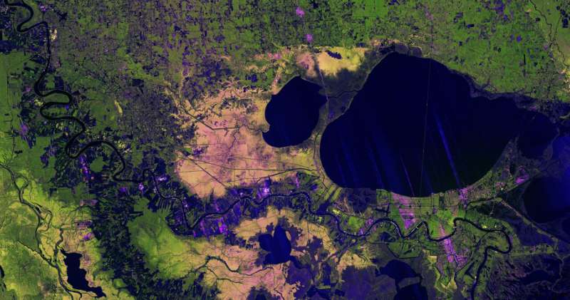
When most satellites tried to photograph Louisiana's Mississippi River Delta on November 29, 2025, all they saw were clouds. But the new NISAR satellite saw right through them, capturing stunning details of New Orleans, forests, wetlands, and farmland below.
The spacecraft uses radar technology that bounces microwaves off Earth's surface instead of capturing visible light like a camera. Those microwaves pass straight through clouds without disruption, creating clear images no matter the weather.
The colorful image released this week shows something remarkable. Scientists can tell the difference between forests, crops, buildings, and wetlands just by how each surface reflects the radar signals back to space. Healthy forests appear bright green because tree canopies scatter the signals in many directions. Thinning wetlands show up in yellow and magenta. Even individual streets in New Orleans are visible based on their angle to the satellite.
NISAR launched in July 2025 as a partnership between NASA and India's space agency ISRO. After months of testing, the mission will release thousands of data files for public download in late February. Researchers have been using early measurements to demonstrate what the satellite can do.
The technology matters for everyday life in unexpected ways. Farmers can track how crops are growing even during cloudy seasons. Scientists can monitor whether wetland forests are thriving or struggling. Emergency responders can assess damage after hurricanes or floods without waiting for clear skies.
The image captures the Lake Pontchartrain Causeway so clearly you can see both parallel bridges stretching nearly 24 miles across the water. West of the Mississippi River, healthy forests glow bright green. Agricultural plots along the riverbanks appear as patchwork squares, with dark areas showing empty fields and bright magenta indicating tall crops.
Why This Inspires
Weather has always limited what we can see from space. Clouds covered the Mississippi Delta region completely when NISAR took this image, yet the satellite revealed intricate details that help protect communities and ecosystems. The partnership between American and Indian scientists shows how international cooperation solves problems that benefit everyone. Soon, farmers anywhere in the world will check crop health regardless of cloud cover, and coastal communities will monitor precious wetlands that protect them from storms.
The satellite's 9-inch wavelength microwaves work like X-rays for the planet, seeing through obstacles that blind other instruments. As climate patterns shift and extreme weather becomes more common, having eyes that never blink through clouds means better information for the people who need it most.
More Images

Based on reporting by Phys.org
This story was written by BrightWire based on verified news reports.
Spread the positivity!
Share this good news with someone who needs it